

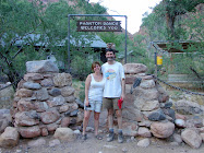
Yes, you read the title correctly ~ we just got back from a rim-to-rim (north to south) backpacking trip through the Grand Canyon. In a nutshell, it was 23.6 miles total, 5761’ elevation down from the north rim to the bottom and 4380’ back up to the south rim. (The south rim us about 1400’ lower than the north rim, thus the difference.) So why do it? Well, we could say, “because it’s there,” but in fact it’s something that we’ve always wanted to do (Suzanne more than Brad, if we’re honest about it.)
So how does one go about hiking through the Grand Canyon? You could go with an outfitter, who would take care of all permits, etc…, but this wasn’t our choice, we wanted to hike it just the two of us. So you’ll need a backcountry permit, and there are two ways to acquire one:
1. Four months before the month you want to camp under the rim (i.e. January 1st for a May trip), you FAX your request to the backcountry office. At that point it’s a waiting game and luck of the draw if they pull your name from all those requesting backcountry permits. (In fact, we tried twice before and were denied – third time was the charm!) Then your backcountry permit comes in the mail, and you’re all set to plan your trip.
OR
2. Go to the backcountry office the day of, or day before, you want to hike in the backcountry, and you may find an opening (someone may have cancelled their trip). The only con with this is that you may not get the campground stops you want. (For example, we wanted to enjoy the hike so decide to stay at Cottonwood Campground 7 miles below the rim on the north side, so we specified that in our permit request. It’s always possible that there’s no open site at Cottonwood – there are only 12 sites – and you have to hike 14 miles to Bright Angel campground in one day – not our choice.)
Now before you even request a backcountry permit, you need to decide which trails you want to hike. If you want to do the main corridor hike, which is what we did, and the only one through the canyon rim-to-rim, you need to decide whether to go north to south, or south to north. Each has it’s pros and cons:
North-to-south
pros: less elevation gain on the way up; less people on the way down.
cons: as mentioned above, it’s 14 miles to Bright Angel Campground, so you either have to hike that in one day (many people do) or stop at Cottonwood Campground along the way; more people on the way up, as the south rim is much more popular than the north rim
South-to-North
Pros: less people as you hike, as you’ll leave earlier than most of the day hikers; less people as you hike out the north rim
Cons: the elevation is gain is much higher on the north rim
Then you have to decide which southern trail to take. (Yup ~ lots of decisions!!)
There is one corridor trail on the north side – the North Kaibab Trail, but on the south side there are two trails, the South Kaibab and Bright Angel. In a nutshell, most people hike the Bright Angel Trail, for even though it’s longer (by about 2.5 miles), it has water along the way (South Kaibab does not) and since it’s 2.5 longer, the elevation gain over 10 miles is easier than the same elevation gain over 7.5 miles.
So that’s all the decisions, but then there are the logistics – if you’re only going rim-to-rim (and yes, some people go rim-to-rim-to-rim), what to do about transportation to the other side?
More on that in the next post………….


1 comment:
Great narrative and photos. Thanks for posting your adventure!
Post a Comment